|
 Thursday Thursday
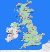
There will again be lots of cloud for many areas during today. Drizzle and patchy rain affects more western areas this morning, this also troubling eastern Ireland. Plenty of low cloud and fog shrouding the hills and coasts of the west too. Further east it should be drier and a few bright or sunny spells will develop in the Midlands, East Anglia and southeast England making it feel very warm here. Staying damp throughout this afternoon on western coasts and hills, with some brighter moments in western Ireland. Little changes elsewhere. Highs at 15C in western Scotland but up to 21C in southeast England.
 Thursday Night Thursday Night
Staying cloudy and mild for most overnight. There will be more drizzle and rain affecting western areas once again, with heavier bursts of rain over windward facing slopes and coasts. More central and eastern parts are likely to be dry with cloud breaking. Staying dry in western Scotland, again with the cloud breaking here. Lows near 7C in central Scotland, 12C in the southeast.
 Friday Friday
A large area of low pressure to the west of Scotland on Friday. Fronts pushing eastwards during the day bringing patchy outbreaks of rain to many parts of England and Wales. More eastern areas are likely to be drier, although again there could be some spots of rain here. Heavier periods of rain in Northern Ireland and the east of Ireland as well as western Scotland, heading north into the afternoon. More persistent rain arriving in Ireland later too. Highs at 12 to 19C.
 Saturday Saturday
A trough of low pressure passes eastwards through the UK and Ireland on Saturday. This will be taking showers with it, some of them heavy. The heaviest of the showers across northern England and Scotland. Sunny spells between the showers, with western parts of Wales, western Scotland and Ireland tending to become drier through the afternoon and evening as a ridge of high pressure builds here. Highs at 12 to 16C.
|


