|
 Good Friday Good Friday
Weak fronts drift west to east, bringing extensive cloud and outbreaks of rain, most persistent for western areas, particularly Wales & north-west England. Intermittent rain for the Midlands, but amounts small, and very little reaching eastern England. Showery across Scotland - rain most frequent in the west. A fresh west to south-westerly breeze. Temperatures 10 to 12C north & west, 13 to 15C Midlands & south-east.
 Friday night Friday night
A weakening cold front passes south-east across England, bringing small amounts of rain to southern counties. Dry for many. Skies clearing for central-northern Britain & Ireland. A few showers for northern Scotland. A west to north-westerly breeze continues, strongest in Scotland, risk up to gale force in the far north. Temperatures dipping to 3 to 6C, perhaps lower in rural areas, resulting in a local slight frost.
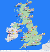
 Saturday Saturday
Dry with spells of sunshine for many, best in eastern counties early morning, then cloud filling in during the day. Showers for north-western regions, moving inland from the coasts in the morning - wintry over Scottish mountains. A few bands of showers also breaking out for east & north-eastern Britain by afternoon. A cool west to north-westerly breeze, strongest in north. Highs 9 or 10C north & west, 11 to 13C south & east.
 Easter Sunday Easter Sunday
High pressure lies to the south-west, whilst a frontal system moves into the north-west. A period of rain is expected to affect Scotland, Northern Ireland and increasingly northern England, although precise detail is uncertain. Central and southern areas are likely to stay dry, with the best of any sunshine around the south coast, particularly the south-west. A cool north-westerly breeze. Highs 9 or 10C north, 12 to 15C south.
|
