|
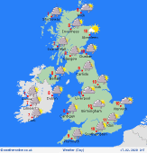 Tuesday Tuesday
Staying cool for all and feeling especially chilly in the brisk westerly wind. Showers with hail spreading inland from western hills and coasts, sometimes falling as sleet and snow to low levels in Scotland and Northern Ireland, but accumulations only brief. Some showers will spread from the west over Wales and England. Largely dry with sunny spells in the east. High temperatures at 4 to 9C.
 Tuesday night Tuesday night
Showers will fade overnight, mostly scattered around western coasts. Showers may stay more frequent in northern Scotland, with snow or hail to low levels. A ridge of high pressure builds from the west, allowing skies to clear. Brisk westerly winds continue overnight. Frost forming where sheltered from the wind. Icy patches. Lows between +3C and -2C, coldest in Scottish glens. Milder near coasts.
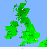
 Wednesday Wednesday
A ridge of high pressure builds temporarily over the UK. The day starts dry with some good spells of sunshine and perhaps a touch of frost. Cloud builds over Ireland and rain spreads from the west later reaching western parts of the UK through the afternoon. Dry most of daylight across eastern counties, although cloud will fill in. Temperatures rising to 6 to 9C, mildest into the evening.
 Thursday Thursday
A trough of low pressure passes eastward across the country, with fronts bringing rainfall to many areas through the day. Heaviest rain in the west in the morning will tend to fade to leave showery conditions, these of hail, or snow on the mountains. Least rain in the southeast. Brisk winds from the south then west, gusting gale force around exposed coasts for a time. Highs 7 to 10C.
|
