|
 Monday Monday
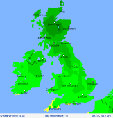
Low pressure is to the east on Monday with a ridge of higher pressure to the west. The resulting northerly flow brings colder weather to all. Gales persist over eastern coasts for a time while early rain clears quickly to the south. Isolated showers may affect northern and eastern coasts, these wintry in places. Drier to the west with good spells of sunshine. A cold day with high temperatures at 3 to 8C.
 Monday Night Monday Night
Cloud builds from the west overnight reaching all areas by morning. Rain, accompanied by very strong winds, moves in behind this spreading across Ireland, western and northern Scotland, northwest England, much of Wales and southwest England by daybreak. Gales likely for western and northern areas. Overnight lows staying mild over Ireland and Northern Ireland at 5 to 9C, 1 to 3C for the rest of the UK.
 Tuesday Tuesday
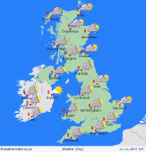
Wet and very windy as fronts pass east through the country. Gales possible for coastal areas around the country. There could briefly be snow over the high ground of Scotland later. Turning milder for a time. Brighter conditions follow later to the west with frequent showers for coastal areas. High temperatures at 10 to 12C for most areas, 7 or 8C for western Ireland.
 Wednesday Wednesday
Low pressure to the north of the UK brings another very windy day with frequent showers, some wintry, affecting western coasts and hills. Plenty of good spells of sunshine though, especially to the east where it will generally be drier. Southern parts of England could see heavier showers at times. Feeling chillier with highs at 3 to 8C.
|
