|
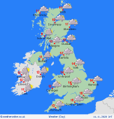
 Friday Friday
Morning rain in East Anglia and southeast England as a cold front clears. It should then be brighter across much of central and eastern England and Wales, as well as the east of Scotland. Showers will be affecting western coast and hills with a general increase in cloud during the afternoon bringing some drizzle to western and south-western areas. Western Scotland seeing further periods of rain and stronger winds with some showers in western parts of Northern Ireland and Ireland. Eastern Ireland should be drier and brighter overall. Highs at 9C in northern Scotland, 14C in southeast England.
 Friday night Friday night
Dry for much of England and Scotland through the first part of the night but with showers still affecting some western areas. Meanwhile, rain will push into western Ireland and Northern Ireland and will spread eastwards across western parts of Scotland, England and Wales through the early hours. Staying mainly dry further east. Lows at 2 to 7C across mainland Scotland, northern England and parts of Wales, 6 to 10C elsewhere.
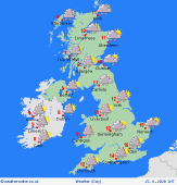
 Saturday Saturday
Cloud and outbreaks of rain through Saturday over most of England and Wales as well as Ireland. Drier towards the southeast of England later for a time before more rain pushes in from the west. Scotland will see largely dry conditions in the morning but more persistent rain pushing in to southern and western areas through the afternoon. Mild across much of England and Wales with temperatures between 12 to 15C. Cooler further north and west with temperatures here between 7 and 12C.
 Sunday Sunday
Morning rain in the southeast, clearing quickly. Brighter and cooler weather follows from the west bringing some sunny spells. Showers affecting western coasts and hills, these heavy and merging into longer spells of rain across northern England and Scotland. A windy day with potential gales affecting western areas. Cooler in the south with highs at 7 to 12C across the country.
|
