|
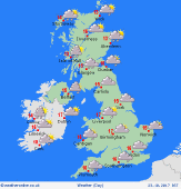
 Tuesday Tuesday
A south-westerly airflow brings mild but dull and damp conditions. Brightest toward the north-east. Some outbreaks of persistent rain for the Midlands and eastern England in the morning. Southern counties should see very little rain. Rain persists for Wales & the north-west much of the day, heaviest over western hills. Showery for western Scotland. Heavier rain returns to southern Ireland later. Highs 14 to 18C, locally warmer south-east.
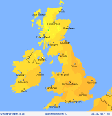
 Tuesday night Tuesday night
Heavy falls of rain continue for Wales & north-west England into the evening and night as a slow-moving front drifts across this area. Heaviest falls over the hills of Snowdonia, Cumbria, and perhaps Lancashire. Possibility of local flooding. Frequent showery rain continues in western Scotland. Largely dry elsewhere. Cloudy and mild in southern Britain. Lows 8 to 11C north, but staying at 12 to 15C south & south-east.
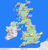
 Wednesday Wednesday
A slow-moving but weak front lies across central & southern Britain, producing a lot of cloud, and patchy light rain or drizzle. Rain may turn persistent again later for the south-west of Britain, also southern Ireland. Brighter toward the north, with sunny spells for north-east England & eastern Scotland. Showery in western Scotland. Winds fairly light, but breezy in north. Highs 15 to 18C for south-eastern Britain, 12 to 14C north & western areas.
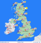
 Thursday Thursday
A slack pressure pattern across the British Isles brings a quiet day to most places. A decaying warm front lies across central England & Wales, producing a lot of cloud, and patchy drizzle in the west. Fairly cloudy for many southern counties, although some brightness may develop. Broken cloud and sunny spells for northern Britain & Ireland. Breezy for Scotland, with showery rain in the far north. Highs 12 to 17C.
|


