|
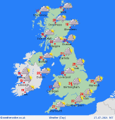
 Sunday Sunday
Low pressure bringing showery rain, heavy and thundery in places, will affect south and southeast England on Sunday. Largely dry and feeling warm elsewhere with good spells of sunshine, however, there is a risk of developing showers across parts of Ireland. Also, low cloud/mist may again affect regions closer towards the North Sea once again, but this should gradually lift through the day. Highs at 19 to 28C with the warmest conditions further west.
 Sunday Night Sunday Night
Thundery rain in the southeast of England will gradually clear offshore overnight. A largely dry night, although spells of rain are likely to push on to some eastern counties of England through the early hours. Far western fringes of Ireland could also see some rain pushing in by morning. Lows at 10 to 16C.
 Monday Monday
Showery rain continues to affect some easternmost regions of England on Monday, in places the rain could be heavy and possibly thundery. Eastern parts of Scotland will see spells of rain push west into more central areas. Meanwhile, a front further west will spread showery rain eastwards across Ireland, Northern Ireland. Wales and into parts of southwest England through the day. Feeling warm still for many with highs Highs at 20 to 27C, cooler across the far north of Scotland.
 Tuesday Tuesday
Low pressure continues to dominate the weather scene on Tuesday. A cold front down the spine of the country will bring spells of rain, heavy for some. Looking to become somewhat brighter further west through the day. Highs at 19 to 27C, cooler across northern Scotland.
|
