|
 Saturday Saturday
A windy morning across most of England and Wales. Gales affecting many areas with gusts of 50mph. The winds easing later in the day. Rain across Scotland, northwest England, Wales and parts of southwest England. This is gong to be heavy at ties and will last for much of the day bringing a risk of local flooding. Drier in eastern England where the sun will come through making it feel very warm. Cooler in western Scotland where it should be dry, but showers for much of western Ireland. A sharp contrast east to west in temperatures with highs at 24C in East Anglia, 11C in western Scotland and Ireland.
 Saturday Night Saturday Night
Cloud and rain in England and Wales tonight, the area moving eastwards through the night. Drier weather follows into Scotland and western parts of the UK and much of eastern Ireland. Some showers affecting western Ireland. The winds easing further. Lows at a very warm 18C in southeast England, 7C in Ireland.
 Sunday Sunday
A front continues to bring rain to central and eastern England and eastern Wales on Sunday morning. The rain only slowly clearing northern England, the Midlands, eastern Wales and central southern England through the afternoon. Staying wet in the east. Cool, brighter weather moves through Ireland, western Scotland, west Wales and western England, although there may be an isolated shower in western Scotland. Highs near 17C in southeast England, 11 to 13C for most other places.
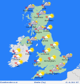 Monday Monday
Wet and windy weather is expected to affect western Scotland and western Ireland on Monday. Dry elsewhere with good spells of sunshine, the best of this in the east and south. Top temperatures 12 to 14C north-west, 15 to 17C south-east.
|
