|
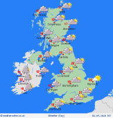
 Monday Monday
A ridge of high pressure remains on Monday for much of the UK bringing sunny spells but also increasing cloud cover to many, after a cold start. However, cloud will gradually thicken across Ireland and into the evening expect patchy, light rain in the far south and far west here. High temperatures at 15C in the north and 19C in the south.
 Monday Night Monday Night
Cloud will continue to thicken across Ireland as well as Northern Ireland and into western Scotland and west Wales with patchy outbreaks of rain here. Elsewhere, it should stay dry with clear spells. There is also the risk for some showers to develop in the far southeast tip of england. A cool night with overnight lows ranging from 6 to 10C in towns and cities, colder in more rural spots.
 Tuesday Tuesday
Low pressure over Iceland with an extending yet weak front still tracking eastwards on Tuesday, expect patchy outbreaks of rain over Northern Ireland, much of Ireland, western and central Scotland, and potentially parts of northern England. Turning bright behind the rain in western Ireland and eastern Scotland should stay largely dry albeit cloudy. With high pressure still over much of England it should stay largely dry but with increasing cloud across southern and central parts. Highs at 14 to 18C.
 Wednesday Wednesday
A largely dry and bright start to the day on Wednesday for England and Wales. Cloudier further north and west with heavy outbreaks of rain for much of Ireland, Northern Ireland and western Scotland through the morning. Breezy here too. During the afternoon outbreaks of rain will affect Wales, the west of England and east Scotland, heavy in places. Staying dry but increasingly cloudy across much of east and southeast England. A milder day with highs at 17 to 21C.
|
